
Inside Nigeria’s Digital Postcode: The GIS and Satellite Data Behind 11 Characters

On 1 October 2026, the Nigerian Postal Service (NIPOST) switched on the National Digital Alphanumeric Postcode. Every addressable building it has captured now carries an 11-character code that narrows from a state to a single structure.
Most coverage has framed the launch as a postal or logistics story. It is better read as the release of a national geospatial dataset. Behind each code sits a production chain: satellite imagery, a nationwide field campaign, GIS processing and validation run state by state.
This analysis follows that chain. It traces how the dataset was built, where space-derived data did the decisive work, how it was augmented and/validated with ground data, and what the first days of public use have surfaced. A follow-up piece will carry answers from the project partners on the questions left open here.
What was built
The system gives each addressable building one code, built from five nested levels and served as a single point on the map. The code belongs to the building, not its occupants; when people move, the code stays.
The code reads from broad to narrow: a two-letter state code, a two-digit LGA, a three-character district, a two-letter area and a two-digit building number. FC 02 D66 JE 06, the example in NIPOST’s online finder, resolves to one residential building in Abuja Municipal Area Council.
The nesting is the analytical feature. At building level, a code identifies a door. Rolled up to the area, district, or LGA level, the same codes give planners, logistics firms, and utilities a shared geography for aggregating their own records.
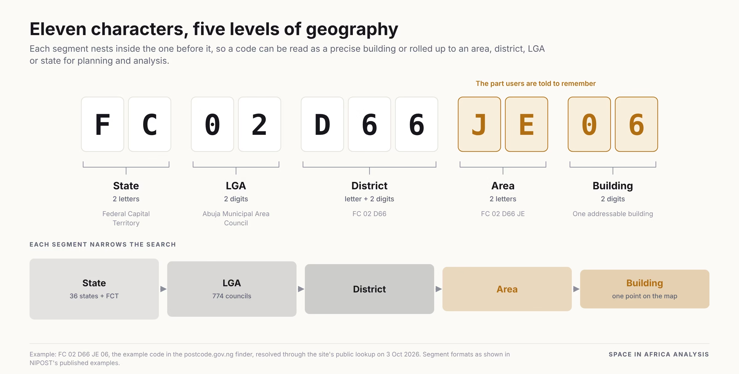
The public lookup returns a point coordinate for each building, not a footprint outline. The record also carries building use, structure type and ownership, flags for delivery point, post office and boundary crossing, and a verification status; the example record is marked unverified. Whether NIPOST holds building outlines internally is one follow-up question.
How the dataset was built
Based on what we can establish, the postcode appears to be the output of a six-stage production chain. Satellite imagery opens and closes it; a door-to-door field campaign carries the middle.
NIPOST led the programme, with Milsat Technologies as technical partner. The National Space Research and Development Agency (NASRDA), the National Population Commission (NPC), the Office of the Surveyor General of the Federation (OSGoF) and other geospatial agencies supported it.
- A spatial framework: The five-level hierarchy sits on an existing national frame. State and LGA boundaries come from the administrative map. District and area units draw on national mapping and enumeration-area demarcation, which preceded validation and ground-truthing.
- Imagery to every field device: An automated processing system turned satellite imagery into basemaps, led by Milsat CEO Teslim Salaudeen. That system pushed basemaps to more than 25,000 field agents at once, in under 15 minutes. This step turns imagery from an archive into a working tool for a national campaign.
- Door-to-door capture: A locally designed mobile mapping tool, also led by Milsat, let teams map every building and road in the country in under nine months. NIPOST’s own correction forms reveal what was captured at each door: 11 structure classes, five use classes, three ownership classes, photos and an address description.
- Validation, state by state: Field teams checked aerially mapped boundaries against on-the-ground conditions, state by state. The mapping logic differed by state, reflecting building density and terrain. A dense Lagos district such as in Mainland, Lagos State, needs different handling from a planned Abuja district.
- Code assignment: Each validated building received its 11-character code. NIPOST now manages the dataset from a dedicated GIS lab, which Postmaster-General Tola Odeyemi described at launch as the place where postcodes are mapped and managed.
- Distribution: Since 1 October, the dataset reaches users through a mobile app, a web finder, an API, web and mobile SDKs, bulk datasets and a private government-to-government corridor. Finding, saving and sharing a code is free for individuals.
Where satellite data was sufficient, and where it required ground validation
Imagery made national coverage possible; fieldwork made each record useful. The two did different jobs, and the postcode needed both.
From above, imagery shows where buildings stand and how far settlements reach. That let planners size the field campaign and gave 25,000 agents a common map to work from. It also provided the ground reference against which aerial mapping was validated.
Imagery cannot tell a shop from a home, count floors reliably in dense districts, or record who owns a building. Those attributes, and the informal addresses many Nigerians actually use, were captured at the door. Every descriptive field in a postcode record traces back to a field visit.
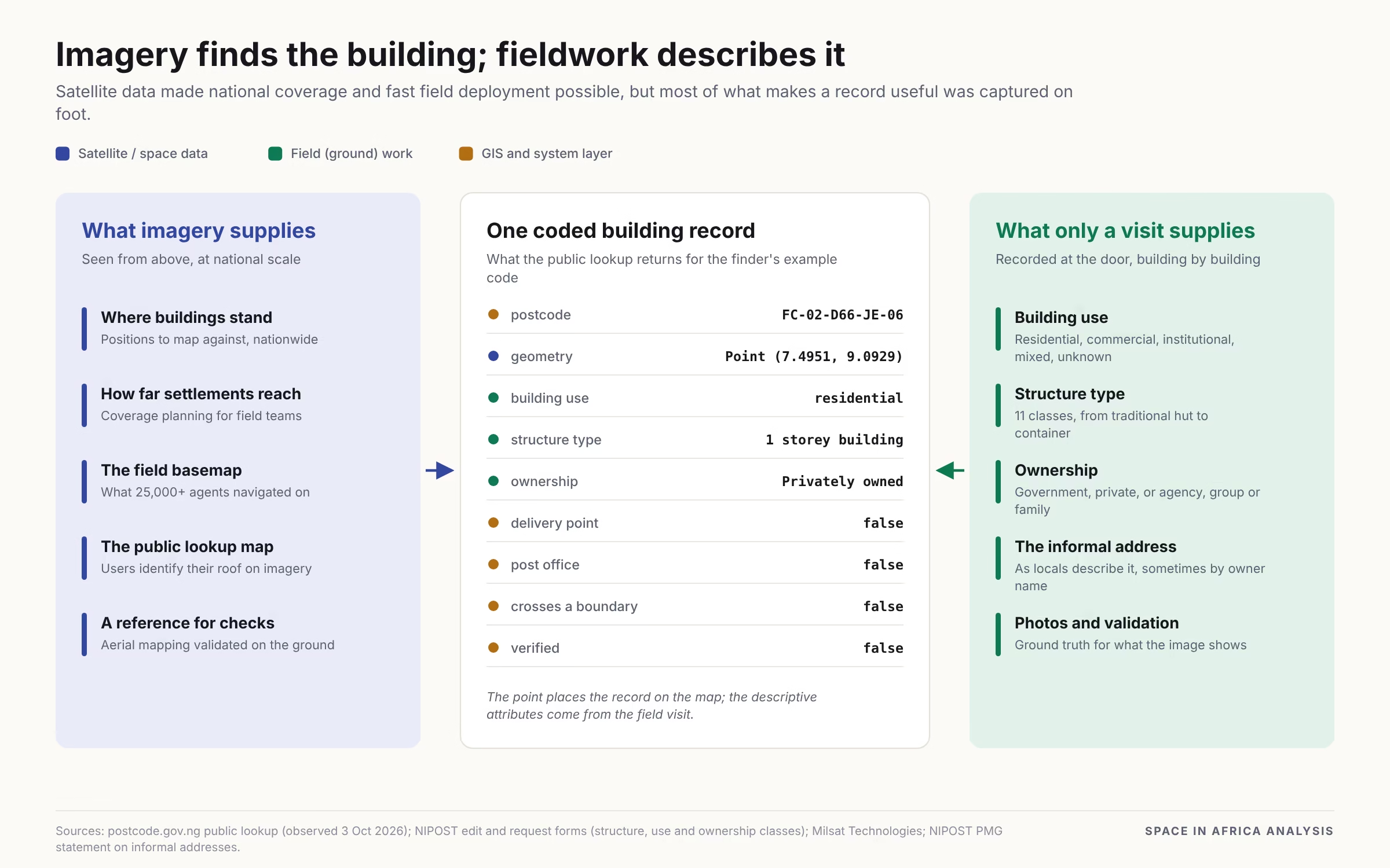
Imagery returns at the end of the chain as the interface. In the app’s finder, users see a satellite basemap with markers for mapped buildings and must tap their own roof; the app does not automatically assign the nearest code. In dense settlements, where GPS alone cannot separate neighbouring buildings, the image disambiguates them.
The public web map displays satellite imagery credited to Esri, Maxar and Earthstar Geographics. Whether the same imagery was used for field capture, or whether other sources were added, is among the questions put to the project partners.
Keeping the map current
As launched, the dataset updates when a user reports a change. All three published update channels are request-driven and reviewed by NIPOST.
- Suggest an edit: corrections to address, structure type, use, ownership or photo, completed within 48 hours.
- Request a postcode: for a missing or new building, with address, building details and up to five photos; a response within 24 hours.
- Register an alias: a business or place name linked to a code; businesses submit CAC registration, ID and proof of ownership or lease, with review within 48 hours.
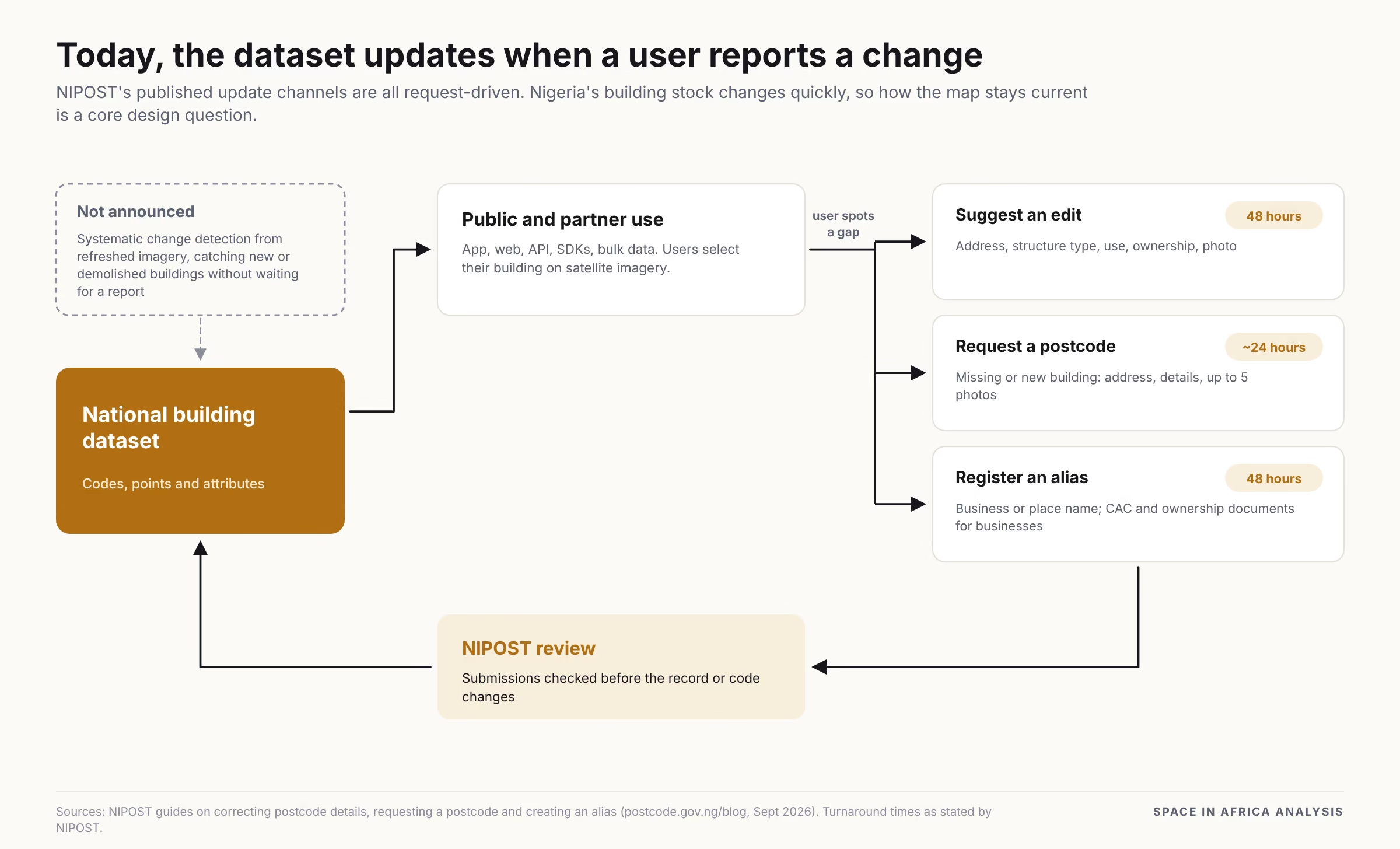
This design lets residents correct what the field campaign missed, and it scales without new survey rounds. Its limit is that the trigger is a user noticing a gap. New estates, demolitions and changes in fast-growing peri-urban areas enter the dataset only when someone reports them.
The alternative is the same tool that started the chain. Periodic imagery refreshes with automated change detection can flag new and removed structures for field verification. NIPOST has not announced whether this is planned, and it is one of the questions for the follow-up.
The first 72 hours
Public use has surfaced four main issues in three days. Each traces back to a design choice higher in the chain.
Names in addresses
On 2 October, TheCable reported that the app showed homeowners’ names alongside building use and type, and that it allowed searches by name. Postmaster-General Tola Odeyemi responded via X that field teams recorded informal addresses as locals describe them, and that owners’ names are often mentioned, “especially in the Northern areas”. In her account, names appear only where no other description exists.
Where the platform runs
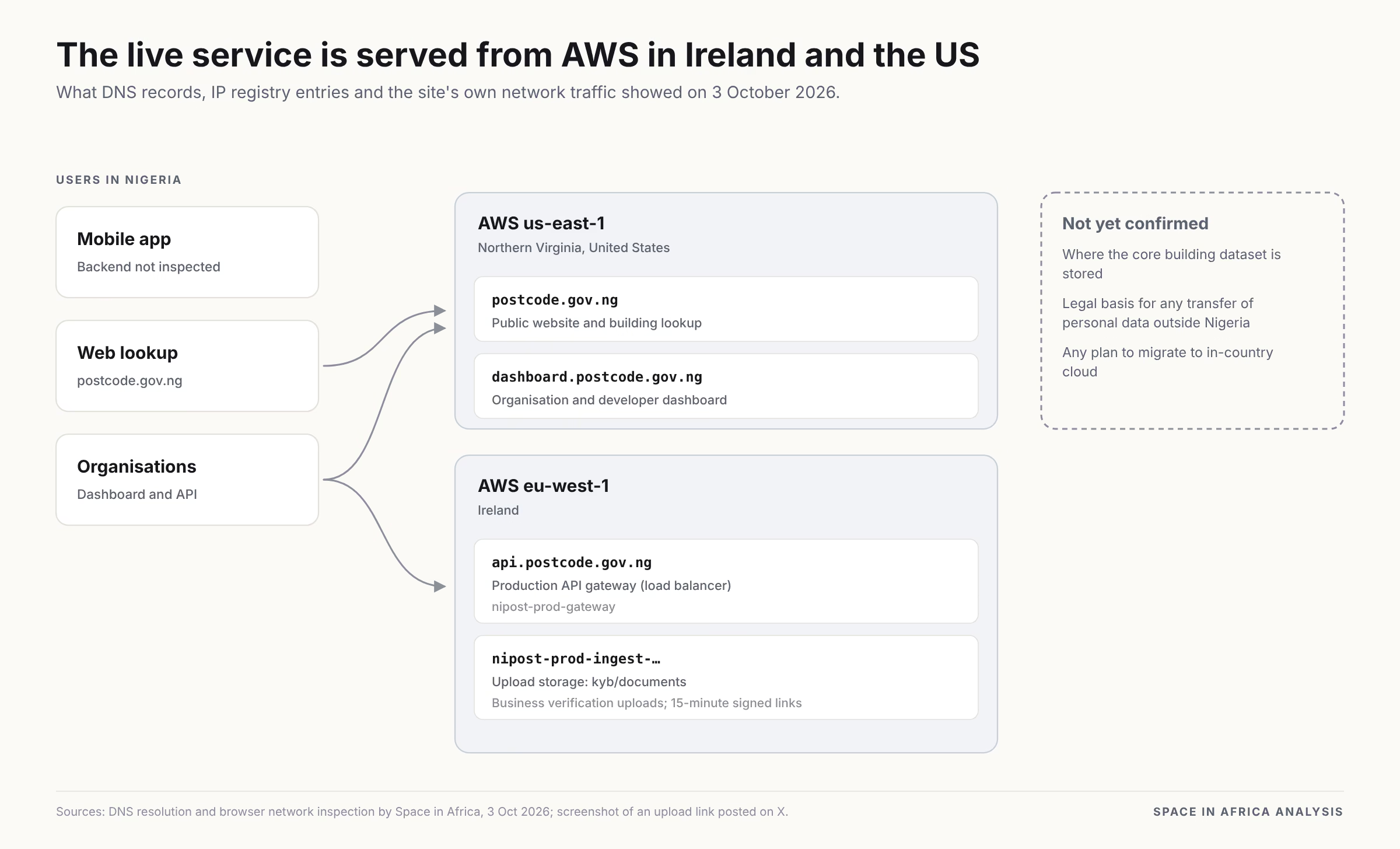
Shortly after launch, a user on X posted a screenshot of an upload link from the platform. It pointed to an Amazon Web Services (AWS) storage bucket in AWS’s Ireland region, filed under business-verification documents. This raised concerns about its use of Amazon Web Services, particularly because some of its infrastructure and user data appear to be hosted outside Nigeria, raising questions about data sovereignty, privacy, and compliance with Nigeria’s data-protection requirements.
We ran our own test on 3 October. In the web finder, we pasted a Google Maps link for a random point in Ikeja, Lagos. The finder returned the nearest coded building, 11 metres away, keeping the final two characters hidden until a building is tapped.
We then traced where that answer came from:
- The website, public lookup and organisation dashboard run on a single AWS server. Our own resolver and Google Public DNS both point to it, and the ARIN registry lists its address in Amazon’s Northern Virginia block (us-east-1).
- The lookup data reached the browser through Amazon CloudFront, via an edge location in Northern Virginia. The system behind it is not visible from outside.
- The production API gateway, api.postcode.gov.ng, is an AWS load balancer named nipost-prod-gateway in AWS’s Ireland region (eu-west-1).
The National Digital Cloud Policy, approved on 17 August 2026, provides the precise framework. It sorts government data into four tiers, from open data that may sit on any compliant public cloud to classified data that must stay on state-controlled infrastructure in Nigeria. Highly sensitive records, including identity and biometric data, must be stored at rest in Nigeria. The policy’s sovereignty provisions still await presidential approval, so those hosting rules are not yet binding.
Read against those tiers, the platform holds layers of very different weight. Public codes and their map points fit the open tier; the lookup already serves exact building coordinates to anyone. Identity documents uploaded for business verification, and the ID details behind proof-of-address certificates, fit the description of highly sensitive records. NIPOST has not clarified how it classifies each layer, where it stores the core building dataset, or the legal basis for doing so.
Length of the code
Early users have described it as 11 characters long. NIPOST says people need to remember only the last four, the area, and the building segments, and that they can save, share, and alias codes in the app. The full code is designed for systems to store and validate, with the street address kept alongside it.
Finding the right building
Nairametrics reported mixed early results: some users found accurate locations, others struggled to identify their building. That friction is expected for an interface that asks users to pick their roof from imagery, and for a first-release dataset still filling gaps.
Why it matters, and what comes next
A building-level address layer is a fundamental dataset of the National Geospatial Data Infrastructure (NGDI), alongside geodetic control, boundaries, imagery, topography, cadastral and demographic data. Without it, the national map cannot connect a person, a service or an asset to a specific door.
With one shared reference, logistics, bank and fintech onboarding, emergency response, identity systems and public investment can point at the same place. NIPOST has already begun listing government service points, including birth and death registration centres, against their codes.
The first release establishes the layer. Its value from here depends on three properties: coverage, meaning how many buildings carry codes; currency, meaning how fast the map tracks change; and access, meaning the terms and location under which the data is held and shared.
Those three tests are where the story now moves. Our follow-up, built on conversations with the project partners, takes up every question this first piece leaves open, from the imagery behind the basemaps to where the data lives.