
The University Centre at the Forefront of Bridging Ghana’s Earth Observation Gap
 Every dry season, wildfires burn through tens of thousands of hectares across Ghana’s northern and middle belt regions. The Ghana National Fire Service and NADMO typically receive alerts after fires have already moved beyond containable perimeters. As a result, Ghana loses an estimated 2% of its forest cover each year, a figure derived from satellite-based assessments that most national institutions cannot produce domestically. Flooding across the Volta Basin has worsened, and the unpredictability of rainfall continues to disrupt agricultural planning in a country where farming employs roughly 40% of the workforce.
Running through each of these problems is the same structural gap: Ghana has long depended on foreign institutions to acquire, process, and interpret the satellite data required to understand and respond to its own environmental conditions.
That dependency is not just about hardware. Ghana lacks enough trained personnel and domestic ground infrastructure to receive satellite data over its territory, process it locally, and route it to institutions that can act on it. Satellites pass over Ghana continuously. What has been missing is the national capacity to use what they generate.
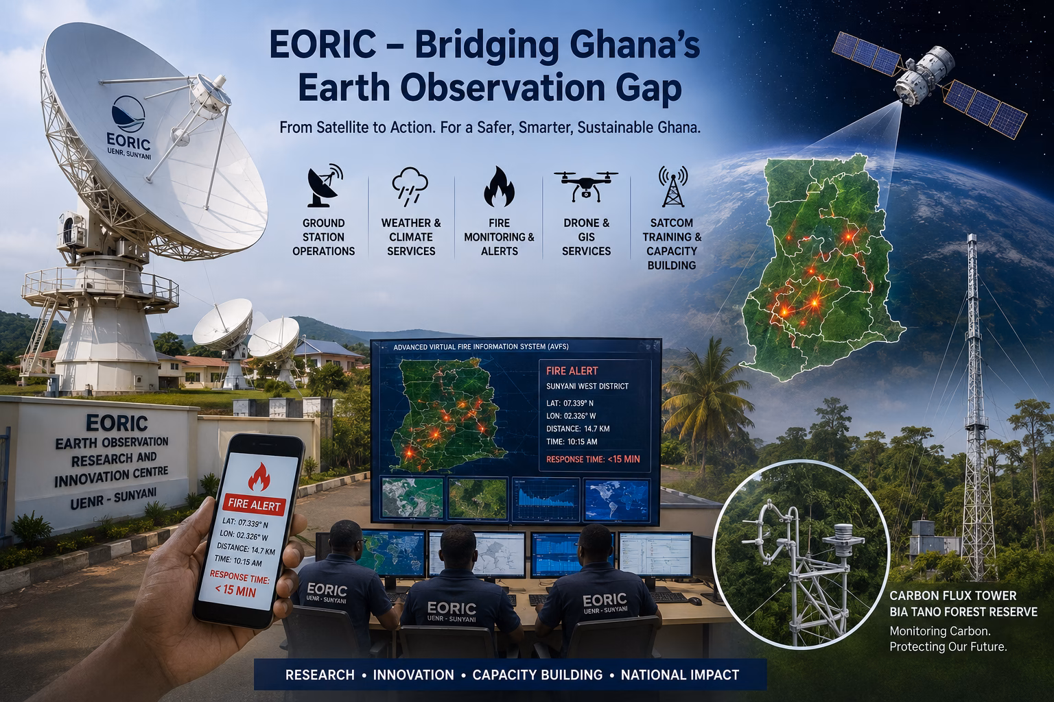
What EORIC Is and Where It Operates
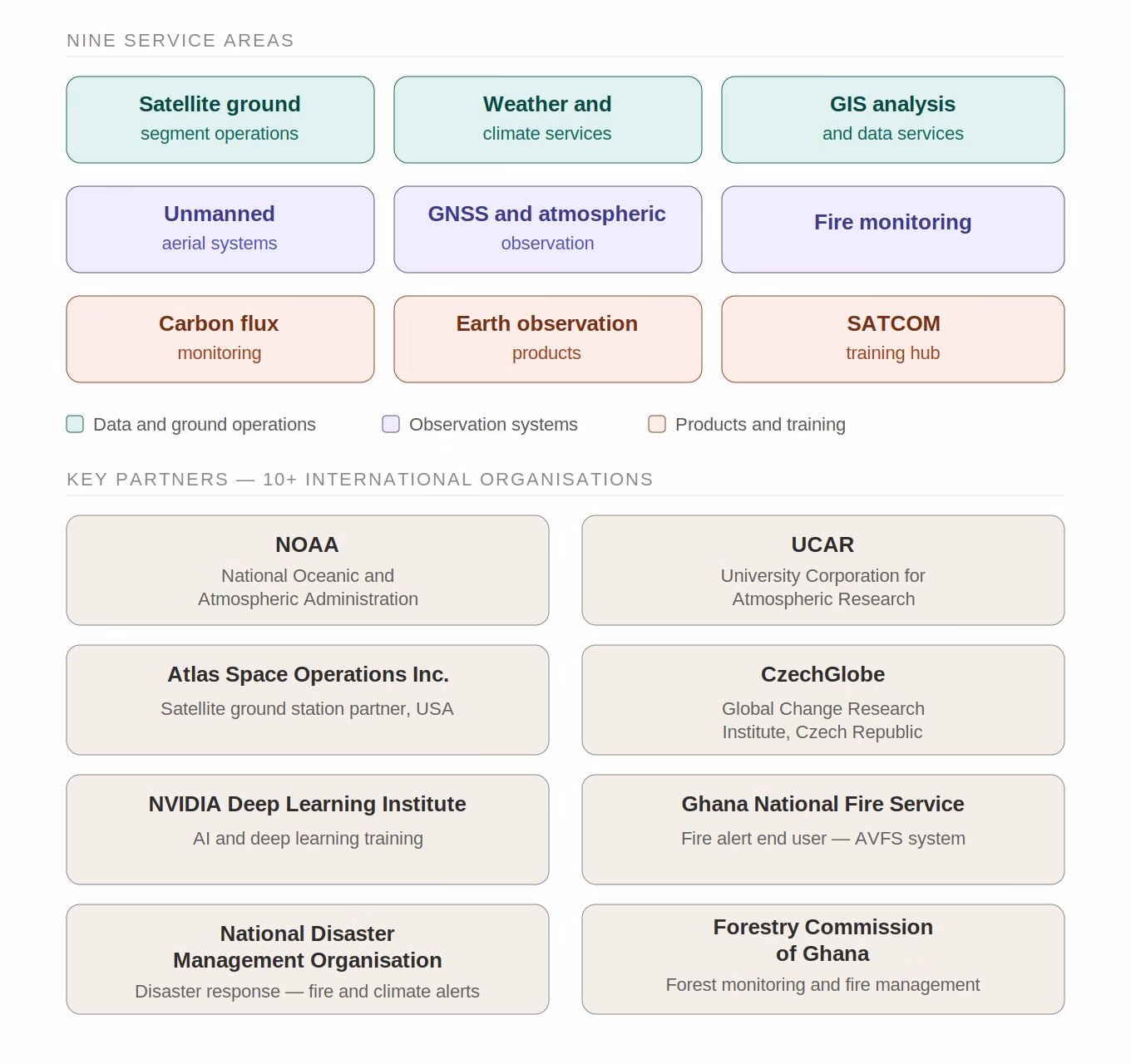
The Earth Observation Research and Innovation Centre (EORIC) is a research arm of the University of Energy and Natural Resources (UENR), based in Sunyani, Bono Region. Its origins trace back to a 2009 AARSE conference in Kampala, Uganda, where Amos T. Kabo-bah, then a Ghanaian graduate student, watched a Dutch remote sensing specialist deploy a satellite ground station and recognised its direct application in Ghana. What followed over the next several years was the construction of a multi-antenna ground station facility on the UENR campus, which now operates across nine service areas.
Those nine areas are: satellite ground-segment operations, weather and climate services, GIS analysis, unmanned aerial systems, GNSS and atmospheric observations, fire monitoring, carbon flux monitoring, earth observation products, and satellite communications training. EORIC’s formal partners include NOAA, UCAR, Atlas Space Operations (USA), NVIDIA’s Deep Learning Institute, Media Broadcast Satellite GmbH, the Ghana National Fire Service, National Disaster Management Organisation (NADMO), AIMS-Ghana, Forest Research Institute of Ghana (FORIG-CSIR), Ghana Meteorological Agency (G-MET), Ghana Skills Development Fund (SDF), Commission for Technical and Vocational Education and Training (CTVET), the Forestry Commission of Ghana, CzechGlobe, and more than ten international organisations in total.
The Ground Infrastructure
EORIC’s ground station on the UENR campus runs five satellite antennas across L, S, X, and C frequency bands, plus a dedicated GNSS referencing station.
- The primary antenna is a 2.4-metre elevation-over-azimuth auto-tracking dish commissioned in 2015. It acquires direct broadcast data from Low Earth Orbit and Medium Earth Orbit satellites, including TERRA, AQUA, NOAA-18/19, S-NPP, Metop-A/B, and China’s Fengyun-3B. This enables EORIC to pull near-real-time environmental imagery without routing requests through a third-party data provider.
- The second antenna is a 3-metre mesh fixed dish receiving from Eutelsat 8W via the EUMETCast-GEONETCast network, a EUMETSAT broadcast system that distributes processed environmental satellite products across Africa.
- The third is a 3-metre X/Y fibre antenna installed in 2016, operating as part of the nine-station global baseline ground architecture for the COSMIC-2 satellite constellation. COSMIC-2 is a joint US-Taiwan programme that uses GPS radio occultation to measure atmospheric temperature, humidity, and electron density. EORIC holds this station under a formal agreement with Atlas Space Operations Inc. (USA) and the University Corporation for Atmospheric Research (UCAR), making it an active node in an international space mission rather than a passive data receiver.
- A fourth element is the GNSS referencing station, jointly operated with UCAR since 2018, supporting atmospheric research and precise positioning. This infrastructure base enables EORIC to commercially offer satellite data hosting, 24/7 antenna maintenance, telemetry, tracking, and command (TT&C) services, RF and systems engineering support, and end-to-end ground station installation consultancy to satellite operators, government agencies, telecom firms, and research institutions.
- The fifth is the 1.5-metre antenna ground station. Regarding this ground station, EORIC is providing colocation services for Media Broadcast Satellite GmbH in Germany to support the SPIRE Mission. The antenna receiver collects a rich, unique dataset to track the oceans, skies, and weather 24/7.
Fire Monitoring: From Satellite to Alert in 15 Minutes
EORIC’s Advanced Virtual Fire Information System (AVFS) draws directly from its EOS-DB and GEONETCast ground stations to run a near-real-time wildfire detection and alert service across Ghana and West Africa.
The system processes satellite passes from TERRA and AQUA, both carrying NASA’s MODIS thermal sensors, and issues geo-located fire alerts with GPS coordinates and directional distance from any user-defined reference point. From satellite scan to alert delivery takes under 15 minutes. Notifications reach users via SMS, email, social media, and a dedicated smart device application.
End users include the Ghana National Fire Service, NADMO, the Forestry Commission, municipal governments, farmer associations, and conservation institutions. In the transition zones between Ghana’s forest and savanna belts, where farming communities face fire exposure every dry season, a 15-minute detection window, rather than a several-hour delay, is a material operational difference. It determines whether a response crew reaches a fire while it is still localised, or arrives at a situation already out of hand.
Training the People Ghana’s Satellite Sector Needs
Ghana’s satellite communications sector has imported most of its technical expertise for ground station installation, maintenance, and operations. That arrangement raises costs, creates single points of failure when contracts lapse, and transfers no durable skills into the national workforce.
In 2024, EORIC launched its SATCOM Training Hub with GHC 2 million (~USD 140,000) from the Ghana Skills Development Fund (GSDF), administered through the Commission for Technical and Vocational Education and Training (CTVET). The objective is straightforward: produce certified satellite communication professionals from within Ghana’s existing engineering and technical workforce.
The curriculum covers six areas: satellite communication fundamentals; GNSS and satellite navigation; remote sensing and earth observation; space systems and operations; disaster management via SATCOM; and space policy, governance, and regulation. Delivery is hybrid, classroom, hands-on practical, and industry attachments.
Furthermore, EORIC is a recognised host of the Global VSAT Forum (GVF) certification programme, an internationally standardised qualification for VSAT technicians. Certified graduates are listed in the GVF Global Installer Database, a verifiable credential with industry-wide recognition. The first cohort completed training in early 2025.
Target employment sectors for graduates include agriculture, health, education, environmental monitoring, and telemedicine, areas where satellite broadband is becoming the only viable connectivity option for Ghana’s rural and peri-urban populations.
The Rest of the Operation
EORIC also conducts carbon flux monitoring in Ghana’s tropical forests using a Carbon Flux Tower, located in the Bia Tano Forest Reserve (Mim, Ahafo Region, Ghana). This facility consists of a 55-meter eddy covariance system designed to continuously measure carbon dioxide (CO₂), water vapour (H₂O), energy exchange, and meteorological variables between the tropical forest ecosystem and the atmosphere. The centre also has an Automatic Weather Station at the Sunyani campus that provides daily weather data for the Centre.
In addition, EORIC conducts GIS analysis and spatial data services, drone-based environmental mapping, and GNSS-based atmospheric observations. These are not separate programmes; they serve the same government agencies, conservation institutions, and international research partners that use the ground station and fire monitoring infrastructure.
The fact that EORIC operates within a public university matters to its long-term functioning. UENR’s mandate in energy and natural resources directly matches EORIC’s technical scope. The university structure creates a direct line from training to applied research to operational deployment, and it means EORIC’s physical infrastructure is a national asset, not tied to a single client or contract cycle.
Ghana faces concurrent pressures on its forests, agricultural sector, and connectivity gap. Whether the country can address any of these using satellite-derived data depends on whether it has domestic institutions capable of receiving, processing, and applying it. EORIC is currently one of the most concrete answers Ghana has to that question.